Resource Mapping | Environmental XPRT
Articles & Whitepapers
-
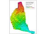
Project - Regional Groundwater Model for the Grand River Basin
Earthfx Incorporated developed a preliminary regional-scale groundwater model for the entire Grand River Conservation Authority area. The objective of the study was to better understand regional groundwater flow in the GRCA and evaluate the interaction between the river and the various aquifer systems in the basin. A key aspect of the study was the integration of multiple smaller-scale models ...
-
EQMS: Taking Biotechnology Quality to New Heights
Biotechnology quality management primarily requires streamlining, managing, and optimizing quality documents such as standard operating procedures. It helps them prevent compliance risks while ...
News
-
Discover Your Local Water Gaps Using the World Water Map
Knowledge is power, as the old adage goes, and when it comes to living more sustainably it can be very useful indeed for both individuals and businesses alike to see what issues face their local communities so they can decide where best to focus ...
Equipment & Solutions
-
Showcase
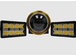
Underwater Vision System
The first smart ROV vision system for low latency vehicle piloting and 3D inspection with powerful edge-computing. 4K Low Latency Video + Stills: Edge computing simultaneously captures raw stills images for 3D modelling while streaming enhanced video for effective vehicle piloting and observation. Simplified Autonomy: The compact design with integrated lights and a DDS data architecture with ROS2 ...


